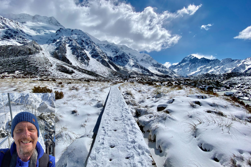
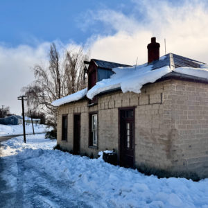
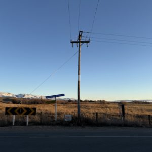
While exploring part of Central Otago during a recent snow dump, I passed this well-known cottage. On this occasion, the snow was piled high, creating what was almost a wall of snow on either side of the road. In a previous life, I believe this place was a general store and post office, meaning it would have been quite the community hub before people moved on and it spent many years as just another dilapidated building.
Five Things to Think About When Photographing Snow
A few emails have arrived asking for some tips on photographing snow, particularly from people who aren’t necessarily out there with a camera every day, but who suddenly find themselves surrounded by a winter wonderland with the family in tow and want to come home with a few good photographs.
So, while this isn’t quite my usual sort of post, I thought I’d put together a few things that might help.
Why is my beautiful white snow grey?
This is probably the most common problem. You look out at a landscape covered in beautiful, clean, white snow, take a photograph and discover that your camera has decided the snow should be a rather miserable shade of grey.
The reason is that your camera is trying to be clever. It sees all that bright snow and thinks there’s far too much light, so it darkens the whole photograph. If you’re using a phone, try tapping on the snow and then sliding the exposure control slightly brighter. If you’re using a camera with manual controls, try increasing your exposure compensation a little.
The important thing is to check the photograph afterwards. If the snow looks grey, brighten it up. If it starts looking like a glowing white sheet with no detail at all, you’ve probably gone too far.
Why does everyone look so dark?
This is another common one, especially when you’re photographing the family standing in front of a large snowy landscape. The camera sees all that bright white snow, exposes for it and leaves the people looking rather like silhouettes.
If you can, position your family so they’re facing towards the light (but be carefully to not have them facing directly into it as everyone will be squinting) rather than having the brightest part of the sky behind them. Your phone’s setting can also help balance the bright snow with the darker faces.
And don’t be afraid of using the flash. Yes, I know, you’re standing outside in broad daylight and it seems completely unnecessary, but a little flash can add some light to people’s faces and make a surprisingly big difference. Photographers will often use flasgh outside in daylight, even if it’s just a little for the eyes!
Why does my snow photograph look so boring?
This is perhaps the biggest challenge of all. Snow can look absolutely magical when you’re standing in it, but photographs have an annoying habit of reducing all that magic to a large white expanse.
The answer is to look for something that breaks up all that whiteness. A person standing in the landscape, a row of trees, a fence disappearing into the distance, a brightly coloured jacket or even a set of footprints can give the photograph some shape and, importantly, a sense of scale.
If you’re photographing the family, don’t necessarily line everyone up and tell them to smile. Photograph them making a snowman, throwing snowballs or trudging through the snow. The snow is the setting. What your family is doing in it is the story.
Where did all the snowflakes go?
If it’s actually snowing, you might expect your photograph to be filled with beautiful, delicate snowflakes. Instead, you look at the result and wonder where they’ve all gone.
Snowflakes can be surprisingly difficult to photograph, especially with a phone. They can be almost invisible against a bright background.
Try finding a darker background, such as trees or a building, which will make the falling snow much easier to see. If you’re photographing children running around, jumping or throwing snowballs, use your phone’s burst or action mode if it has one. With a camera, a faster shutter speed will help freeze all that activity.
Of course, you could also embrace the blur. Sometimes a slightly blurred photograph of a child charging through the snow tells you far more about the day than a technically perfect photograph ever could.
Don’t forget that your camera is getting cold and wet
This is the one that can turn a lovely day in the snow into a very expensive trip to the camera shop.
Snow and cameras aren’t necessarily natural friends. Keep an eye on moisture getting onto your lens and, if you’re using a camera, remember that batteries don’t particularly enjoy the cold. Keeping a spare battery in an inside pocket can be a very good idea.
The other thing to remember is condensation. If you’ve been outside in the cold and then bring your camera straight into a warm house, moisture can form inside and around it. If possible, put the camera into a sealed bag before going inside and allow it to warm up gradually.
Bonus Tip: Take Lots of Photographs
Allow yourself to play! Try different settings, different angles, different focal lengths and different ways of using the light. Don’t just take one or two photographs and then move on. Take twenty. Take fifty. Take a hundred if you want to. Once you’re finished, you can always go back through them and delete the ones you don’t want.
If you take two photographs, you’ve got a fairly slim chance of getting exactly the photograph you’re hoping for. Take twenty, however, and your odds of finding a good one are suddenly much better. And if you’re running out of space on your digital memory, have a quick look through the images and delete a few of the obvious rejects.
As an example, I took nearly forty photographs of this particular tree in the Strath Taieri, moving around to all sorts of different positions, trying different focal lengths and making adjustments to the exposure and the way I was working with the light. I wanted to make sure I had the photograph I was looking for. By the time I’d finished, I was fairly cold, but fortunately the car’s heating was more than sufficient to warm me up again.
And that’s really the beauty of digital photography. You can experiment, make mistakes and try again. The only thing it costs you is a little time, and perhaps a few gigabytes of storage.
And finally, probably my best piece of advice is this: don’t spend the entire day worrying about getting the perfect photograph.
I’d been in Port Chalmers in the early part of the morning and, having completed a few errands, I headed back to Dunedin. It was one of those mornings when the weather hanging over the harbour seemed a little indecisive, and the higher clouds even more so. Along the drive to and from Port Chalmers, there are all these bays and inlets that create interesting shapes and views if you take the time to explore some of the roads that branched off State Highway 88. On this occasion the light kept changing with patches of brightness appearing through the clouds before disappearing again a few minutes later. It was the sort of day that encouraged a little wandering, so rather than simply heading home, I found myself taking the occasional detour, stopping whenever the road offered a different view across the water and towards the hills.
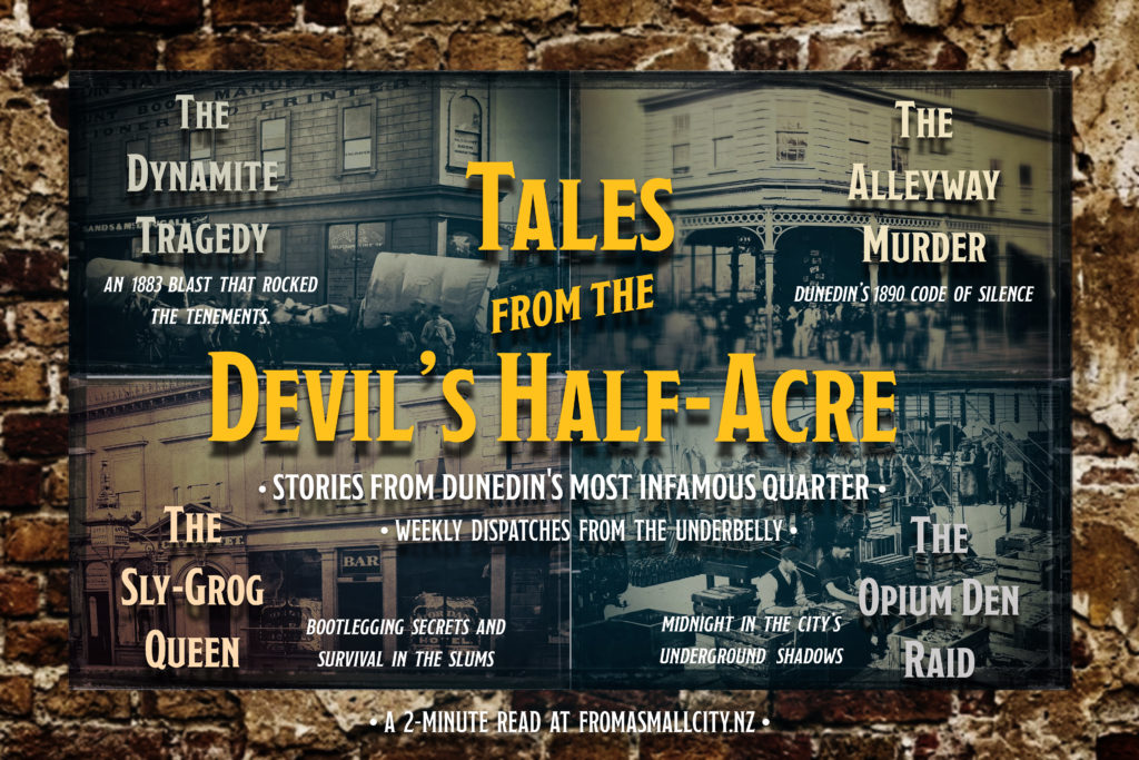
Tales From The Devil’s Half-Acre – The Alleyway Murder
A little taste of the next Dispatch from The Devil’s Half-Acre. One night while walking along Walker Street, a man was attacked. In self-defence he grabbed a knife and stabbed his attacker. When two men and a lady appeared on the scene, saying that they had witnessed the whole affair and that if he hadn’t murdered the man, they would have. Nobody saw anything, and nobody heard anything.
Daily Photo – Banks Peninsula from Lighthouse Road
On my first morning in Akaroa, I decided to do a little exploring of the French town on foot and spent the best part of the morning wandering in and out of shops, stopping at cafes and venturing out onto the jetties. When that was done, I took the car up into the hills to get a more scenic view of all the bays and inlets that there are to see. I headed up along Lighthouse Road, climbing steadily away from the town and into the hills, where the views seemed to open up with every turn. Below me, the peninsula stretched out in a wonderfully complicated collection of bays, coves and little fingers of water, with the surrounding hills rolling away into the distance. It was one of those drives where there was a temptation to stop every few minutes, simply because each bend in the road seemed to reveal another view that was even better than the last. From up there, it really was easy to understand why so many people seem to like Akaroa and the surrounding countryside.
On a drizzly afternoon on Queen Street, I found myself standing in front of a rather wonderful reminder that Auckland wasn’t always made of glass, steel and buildings that look as though they were designed by the same person.
The Guardian building sits among the modern towers of the CBD, an ornate survivor from another Auckland, when buildings were built from completely different materials. Its neo-Renaissance façade is covered in the sort of detail that seems increasingly rare these days, from the grand columns of the entrance to the rather splendid copper-clad clock that hangs above the street. Once the home of the Auckland Stock Exchange, and the New Zealand Insurance Company’s administration, the only housing in the building was the caretaker’s flat on the eighth floor.
In the wet, the building seemed to take on an entirely different character. The rain-darkened pavement reflected the grey sky and the facade, softening the whole scene and making it look even more like a survivor from another time.
Leaving Kokonga, or what I could see of it, I continued along Highway 87 as paddocks, sheds, farm buildings, hay bales and livestock came and went in the white, misty gloom. A short time later, I arrived in Kyeburn to find that things weren’t much better. However, as I headed towards Ranfurly, the skies gradually cleared, revealing a crisp, cloudless blue sky. A heavy blanket of fresh winter snow covered the rolling high-country hills, while dark tyre tracks cut through the fields, where wire fences stretched into the distance past scattered livestock braving the chill. All of this was backdropped by the majestic, snow-clad Hawkdun Ranges rising sharply against the horizon, the scene captured the serene, rugged beauty of a classic South Island landscape.
On occasions, there are moments that give you a real understanding of just what elevation can mean, and my arrival in Kokonga, in the Maniototo Basin, was one of them. I’d been travelling for some time through the Strath Taieri and, thanks to a recent snowfall, the surrounding hills were covered in crisp, white snow. However, with the area mostly sitting in a broad, flat valley framed by the Rock and Pillar Range, the snowline could be clearly seen on the surrounding hills, leaving the valley itself clear and cool on a typical winter’s day.
Kokonga, on the other hand, sits on the edge of the Maniototo and Strath Taieri basins, and thanks to a short climb in elevation, the transformation was quite remarkable. The clear roads and surrounding farmland had been replaced by a patchwork of white, disappearing into the mist beyond.
Not far from where I took this wonderfully geometric photograph is Dowling Street, a street that owes its origins to the need to make central Dunedin a more accessible place. It was while looking for information for my current series, Tales from the Devil’s Half-Acre, that I came across an interesting wee tale that I’d like to share.
When Dowling Street was first created, a substantial amount of blasting was required to form the cutting. The mayor at the time, John Barnes, awarded the job of supervising the work to his son, William, who, importantly as it turns out, had no qualifications whatsoever for the position.
What transpired was nothing more than an astonishing piece of bad luck and sensational tragedy. The blasting that took place, naturally enough, sent massive pieces of rock and boulders flying in all directions. One of these was catapulted through the air before crashing through the ceiling of a nearby business, striking a Mrs Finch.
Mrs Finch, the poor thing, just happened to be working quietly upstairs when the huge rock came crashing in from above. Naturally, it killed her instantly, and I dare say she wouldn’t have had the faintest idea what hit her!
I’d spent the evening dining on pizza and beer and, when at last it was time to depart, I settled the bill and went in search of a bus! Not more than a few minutes later, I spotted my means of transportation disappearing into the distance. I took this as a sign from the Universe, and one that must be followed immediately! So, I went back to the establishment I had just departed from, ordered another beer, and decided to study the bus timetable a little more carefully!
Tales From The Devil’s Half-Acre – The Dynamite Tragedy
A little taste of the next Dispatch from The Devil’s Half-Acre. In July 1883, George Stephenson followed his estranged wife Mary through the streets of Dunedin with a rather more sinister plan in mind than simply asking how her day had been. What followed became one of the city’s most horrific murder-suicides, involving a stick of dynamite, a match head, and a blast that shook the neighbourhood.
Another selection from my Live Feed with a mostly wintery feel and a few that haven’t been published yet. You can head over to the page right now using this link: Live Feed
Daily Photo – “I wander thro’ each charter’d street”
Daily Photo – P!nk & her 2009 Funhouse World Tour.
Wandering in a confused haze through an exhibition that I knew nothing about and didn’t understand, I happily settled on the fact that I know nothing about fashion! Fortunately, there were lots of extremely useful information cards that were a bit of a lifesaver. For example, thanks to these cards, I’m able to tell you that this vibrant and theatrical little number was worn by P!nk during her 2009 Funhouse World Tour. Furthermore, I can tell you that the ringmaster costume was designed by Bob Mackie, who apparently is a bit of a legend in the fashion world!
Long before Europeans arrived on the shores of New Zealand and set about naming everything after themselves, their friends, or somewhere they’d left behind in England, Māori already had perfectly good names for pretty much everything.
Here in Dunedin, the prominent mountain we now know as Mount Cargill was known to Kāi Tahu as Kapukataumahaka. While the name doesn’t lend itself to a neat, literal translation, it carries the meaning of a place where food was gathered, particularly where birds such as weka and kererū were hunted and snared while feeding on the berries of the kapuka, or broadleaf tree.
So, long before Mount Cargill was Mount Cargill, it was a place where people went looking for dinner. Which, when you think about it, is probably a far more useful name for a mountain.
There are few things quite like a winter drive through the Strath Taieri. On this particular day, the landscape had been given a fresh dusting of snow, turning the wide-open paddocks into a patchwork of white, with the hills disappearing into the mist beyond.
I stopped, as I am inclined to do when faced with a view that looks as though it has been waiting patiently for someone to take its photograph, and found this solitary tree standing in the middle of it all. It seemed rather pleased with itself, quietly carrying on while the weather did its best to make the rest of the world disappear.
Daily Photo – Cactus Garden in the Winter Glasshouse
Today I bring to you the cactus, which allows me to share a story that I can assure you is absolutely true and fits neatly into the “idiot has a gun” category.
In February 1982, an Arizona man and his friend headed out into the desert to engage in a little “cactus plugging”. For the uninitiated, cactus plugging is a rather simple activity. All you need is a gun and a giant cactus and, like many activities involving firearms and questionable decision-making, it generally goes well until it doesn’t.
On this occasion, the pair came across a cactus reported to be between seven and eight metres tall, which would have made it well over a century old. Now, the thing about this particular cactus that features in our story is that this type doesn’t grow arms until they’re around 70 years old, and the monstrous specimen the pair had chosen had side arms later estimated to weigh around 230 kilograms, making the cactus somewhere between 150 and 200 years old. Well, the pair happily fired away at the cactus, repeatedly shooting into the base, naturally weakening the trunk. When their target didn’t immediately fall, they continued firing in the hope of toppling the mighty beast.
What happened next, I can only imagine, was one of those moments in life when time seems to stand still while everything happens in slow motion. As they continued firing, one of the massive side arms suddenly broke free, falling directly on top of one of the men and pinning him to the ground. The now unstable cactus, no longer able to support its own enormous weight, then collapsed on top of him.
Faced with his friend being crushed beneath a giant cactus, the other man ran several miles for help, but by the time emergency crews reached the remote location, he was already dead.
There are, I imagine, countless ways to leave this world. Being flattened by a cactus in the Arizona desert, has to rank among the more unusual.
Daily Photo – The Dinning Room at Larnach’s Castle
When William Larnach moved into his peninsula mansion, if he’d had a fridge, his “to-do” list probably wouldn’t have fitted on it. In fact, it was more a case of asking what had been finished.
Things he would have proudly been able to tell his wife Eliza he’d finally gotten around to completing included erecting the three-storey stone shell, constructing the central tower, securing the main roof, framing the exterior verandahs, completing the temporary estate cottages and roughing in the primary interior layout.
His to-do list, however, was just a tiny bit longer. Among other things, it included completing the lower apartments, enclosing the verandahs, carving the master ceilings, laying the interior woodwork, constructing the grand staircase, building the ballroom, finishing the ground-floor structural stonework, shipping 20 tons of glass panels from Venice, and sourcing premium native New Zealand timber to cover the raw brickwork. Then there were the grounds. Massive piles of construction debris had to be cleared, dense bush cut back, muddy clay fields graded, windbreaks established and the footprint of a formal garden laid out.
So unfinished was the building that the Larnachs continued to live on a building site for another 12 years as various parts of the house were completed. The highly elaborate carved ceilings in the main foyer and dining room were so specialised that they alone took six and a half years to finish. Building his grand home had taken so long, and demanded such extraordinary craftsmanship, that Larnach lived in a fully completed house for just 11 years before his death in 1898. A lot of that time he spent in Parliament in Wellington, so how much time in actually spent in his home is hard to say!
I’d spent the early part of the evening having dinner with a group of long-time friends, an occasion that quickly confirmed to everyone present that, despite the passing years, I hadn’t changed one bit. I’d arrived carrying a camera and tripod, immediately reassuring the gathering that there was every chance I’d disappear at some point in search of a photograph. With that expectation firmly established, I did what any sensible person would do and went in search of the first round of beers to get the evening underway.
Dinner itself was a complete success, if your definition of success involves dripping food down the front of your top while simultaneously scattering the rest in an impressively constructed semi-circle around the edge of your plate. Not content with that achievement, I rounded things off by leaving a trail of beer drips that started at the bar and led all the way back to our table, courtesy of the pint I was apparently meant to be in control of.
Having made what I felt was an entirely suitable impression, and reassured everyone that I remained exactly the same slightly chaotic person they’d known for years, I said my goodbyes and went in search of a bus home. Naturally, the camera and tripod came with me. After all, there was no point carrying them around all evening if I wasn’t going to stop somewhere on the way home and take a photograph
The first morning I was in Akaroa, I called into the farmers’ market and took the opportunity to have a slow wander around the various stalls. After poking my nose around for a while, I stopped at a food truck called Zed’s Shed and ordered a bacon butty for brunch before setting off in search of caffeine.
One of the good things about Akaroa is that the township is wonderfully suited to walking. Spread across several bays, you can happily spend your time aimlessly drifting in and out of shops, rummaging through shelves, or doing what I did: sit on a park bench while dripping grease and coffee down the front of my shirt, making it abundantly clear to everyone I met that I really shouldn’t be allowed to eat in public without a bib.
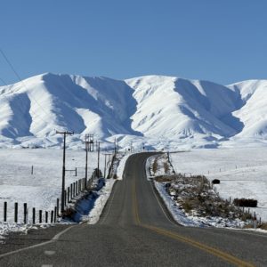
Daily Photo – Main Street & Gimmerburn-Waipiata Road at dusk
With a few days free and a recent snowstorm having left much of Central Otago looking beautifully white, I headed off in search of snow photos. The plan was simple enough: drive until I found something interesting, stop far too often, and hope the weather cooperated. So, naturally, the first photo I post from the trip is a non-snow photo.
After spending the day criss-crossing the Maniototo, stopping whenever the light caught my eye, the landscape demanded another look or the snow got really interesting, I eventually rolled into the tiny settlement of Waipiata. I found my accommodation, dumped my bags in my room, and immediately headed back outside. It had been a long day in the car and I needed to be outdoors for a bit. As dusk settled across the wide-open landscape, the last of the daylight softened the empty streets and surrounding hills, giving the little settlement the sort of quiet charm that only seems to appear at the end of the day.
There are mornings when the weather seems unable to make up its mind. This was one of them. I was driving back from Port Chalmers to Dunedin when a curtain of rain swept across Otago Harbour, turning the familiar view into something altogether more theatrical. Dark clouds hung low over the hills while shafts of sunlight found improbable gaps, pouring through as though someone had quietly opened a door in the sky.
I pulled over because some scenes deserve more than a glance through a windscreen. They ask for a little patience.
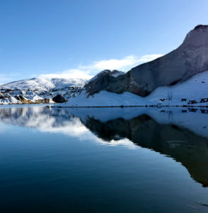
There’s something deeply humbling, and slightly alarming, about rounding a bend to find a geological titan swallowing the horizon. Spread out before me was the Rock and Pillar Range, vast and imposing in a humble sort of way. The range didn’t peak in the sharp, dramatic fashion of the Southern Alps. Instead, it rose in a massive, undulating wall, with deep, icy gullies that looked from a distance like the face of a wrinkled old man, showing the weariness of time. Below this blanket of winter, the lower foothills rested in a desolate expanse of dry tussock, with weather-beaten rock formations littering the ground in every direction.
The contrast was striking. A clear blue sky above a frozen mountain range, and a prehistoric plain at my feet. I pulled the car over at a signposted rest stop, mesmerised by the sheer, unbothered scale of it all. Time seemed to stand still, frozen like the surrounding landscape.
Daily Photo – Auckland’s Te Komititanga Square & Ferry Building
There’s something exhilaratingly miserable about exploring an unfamiliar city in a downpour. I stood in the centre of Auckland’s Te Komititanga Square, water cascading off the brim of my hat in a steady, miniature waterfall, watching the locals navigate the deluge with that effortless dignity only locals seem to possess. They didn’t run so much as simply glide beneath enormous, structurally sound umbrellas, looking as though they were modelling rainwear from a high-end catalogue.
I, meanwhile, was completely soaked. An earlier decision not to bring a jacket was coming back to haunt me. My vest had surrendered twenty minutes earlier, absorbing water like an oversized sponge, and my left shoe had developed a rhythmic squelch that sounded like the death throes of a dying amphibian. The tiles and neatly laid walkways, which I’m sure are beautifully picturesque in the midday sun, had transformed into a treacherous obstacle course covered by a slick film of pooling water.
I took three cautious steps, immediately lost my footing, and performed a brief, frantic tap dance to avoid both my camera and my skull cracking open in the middle of one of Auckland’s most public places. With a desperate flailing of my arms as the rain pelted down, I somehow managed to retain my equilibrium and assured the onlookers that I’d been doing my own stunts for years now.
It was at that point I came to the conclusion that it was time to abandon the square and head for the dry sanctuary of a nearby covered arcade.
Since we’ve had two photos already this week from my recent trip to Australia (which was really just hanging out in Melbourne and riding the free trams), here’s a third. This one, however, is from an earlier trip several years back. I ended up in Lindenow, a small country town about three hours’ drive east of Melbourne, but less than an hour from the lovely and ever-popular Lakes Entrance.
Victoria has a habit of punching well above its weight. Along with countless small towns and spectacular scenery, the state has produced more than its fair share of remarkably well-known Australians. Among them are Australian cricketing great Shane Warne, singer Kylie Minogue, actress Cate Blanchett, and global media mogul Rupert Murdoch.
It can also lay claim to Chloe Dillon, Harley Reid, Nick Daicos, Molly Dixon and Troy Candy. Now, I don’t know who any of those people are, but according to a website I stumbled across, apparently they’re pretty famous. Just what they’re famous for, well, I couldn’t say. My guess would be wearing very little and dancing on TikTok.
Daily Photo – An Evening In Shepparton Regional Park
An early evening stroll led me deep into the heart of Shepparton Regional Park, a uniquely captivating Australian landscape. I found myself completely surrounded by the magnificent, sprawling floodplain forests of classic River Red Gums. As the fading daylight dipped below the horizon, a warm, golden sunset drifted softly through the dense canopy. The ancient trunks cast long shadows across the forest floor, framing the Australian twilight.
Standing here among the monotony of the trees, it is easy to see how a single step off the track could leave you utterly disoriented and lost. It was precisely this unforgiving, vast wilderness that colonial bushrangers relied upon, vanishing into the dense scrub to escape the law and evade the police for months on end.
What Australians historically term a ‘bushranger’ is really what the rest of us would call a common thief or outlaw. The most celebrated among them include figures like Ned Kelly, Harry Power, Daniel ‘Mad Dog’ Morgan, and Ben Hall, a collection of deeply anti-social fugitives wanted for an impressively long list of offences. They had a knack for vanishing into the unforgiving landscape, occasionally emerging to rob passing travellers, stagecoaches, and wealthy landowners before melting back into the scenery, sometimes not to be seen for months or even years. As far as hiding places went, Australia was so bafflingly immense that the opportunities for disappearing were almost endless, requiring a genuinely heroic level of commitment from the local constabulary to track the outlaws down. Modern Australians seem to love these characters as beloved folk icons, when in reality they were largely a collection of bullies and murderous thugs looking out for little more than their own gain.
I took this photograph somewhere along Nathan Road, although I couldn’t tell you exactly where. To be honest, it hardly matters because there are countless buildings like this throughout Kowloon. They aren’t landmarks, yet together they define the city.
At first glance it’s simply an ageing concrete building. Then the details begin to emerge. Washing hangs from balconies high above the traffic. Windows are propped open despite the humidity. Every floor has been enclosed, altered, repaired, extended, or adapted over the decades until the building has developed its own wonderfully untidy character. Air conditioning units cling to the outside walls in such numbers that they seem almost structural, as though removing them might cause the whole place to collapse.
The more I stood there, the more I realised I wasn’t looking at architecture. I was looking at thousands of ordinary lives stacked one on top of another. Homes above offices. Businesses beside apartments. Families, shopkeepers, accountants, students and retirees, all sharing the same block while Nathan Road flowed relentlessly beneath them.
It struck me that this was exactly the sort of thing I like about traveling. Not experiencing a famous attraction or a postcard view, just an ordinary building quietly getting on with the business of simply being. In this case, simply being Kowloon.
I spent an afternoon near the banks of the Goulburn River, which has the honour of being northern Victoria’s largest river. Yet this peaceful stretch of water was once one of the busiest crossroads in colonial Victoria. Long before Shepparton existed as the quiet city it is now, when gold was discovered and everyone went bonkers heading for Victoria’s northern goldfields, sooner or later every miner came to a single river crossing known as McGuire’s Punt. It was a simple and crude, yet effective, set-up, with a decidedly rickety and primitive punt that carried people from one muddy bank to the other by way of a rope.
That also made it an ideal place for the less respectable members of society to take advantage of the busy crossing. Miners carrying pokes full of gold dust, merchants with wagons of supplies, wandering gamblers, escaped convicts, bushrangers, and every variety of drifter all passed through here, while others looked for an opportunity to relieve someone of their possessions.
These days the Goulburn drifts quietly past towering river gums, yet it’s fascinating to think that this tranquil river once held up the entire traffic of the Victorian gold rush. Before there was a town, before there were bridges, there was simply a river, a punt, and a queue of hopeful souls waiting to cross.
Stepping inside St Paul’s Cathedral in Melbourne is a bit like walking through a time machine. One moment you’re surrounded by trams rattling along Flinders Street and thousands of commuters hurrying to catch a train. Next, you’re standing beneath soaring arches where the noise of the city simply disappears. It’s quite the contrast.
What I particularly enjoyed, though, was discovering that the cathedral has one of Australia’s more unusual traditions. Hidden away inside is a set of bell-ringing ropes connected to thirteen enormous bells housed in the tower. Rather than chiming automatically, these bells are still rung the old-fashioned way by teams of volunteers. It’s called change ringing, and instead of playing tunes, the ringers perform intricate mathematical sequences that can take hours to complete. To the untrained ear it sounds delightfully random. To the people pulling the ropes, it’s a carefully choreographed performance requiring remarkable concentration and teamwork.
I find something rather comforting about that. In an age where almost everything is controlled by computers, there are still people happily spending an afternoon hauling on ropes simply to keep a centuries-old tradition alive.
The cathedral itself is magnificent, but it’s knowing that somewhere above your head a group of enthusiastic bell ringers is quietly practising an ancient art that makes the place feel just that little bit more special.
If buildings could talk, Belfast City Hall would probably spend half its time gossiping about pigeons and the other half complaining about people climbing onto its lawns for the perfect photograph. Completed in 1906, it’s an absolute showpiece, built to celebrate Belfast’s brief but spectacular spell as one of the richest cities in the world. By day it’s impressive enough, but at night, when it’s bathed in coloured lights and reflected in rain-soaked pavement, it becomes one of those buildings that practically insists on having its photo taken.
The quirky part of its story, though, lies beneath your feet.
Hidden under the grand entrance is a sealed time capsule placed there when the foundation stone was laid in 1898. Packed inside are coins, newspapers and documents from Victorian Belfast, all intended for people who haven’t been born yet. It’s the architectural equivalent of stuffing things into the attic and hoping your great-grandchildren find them one day.
I rather like that idea. While thousands of tourists wander around admiring the domes, columns and Christmas lights, there’s a little snapshot of everyday Belfast quietly waiting underground. One day someone will eventually open it and discover what people considered worth preserving. Hopefully they’ll also find instructions on how to keep the pigeons off the statues, because judging by the evidence outside, that mystery still hasn’t been solved.
I’ve shared images from this location before, it’s offical name is Matakea/Shag Point and you’ll find it a few minutes north of the small town of Palmerston in East Otago. There’s a tiny, deeply indented natural boat harbour there that was originally used by Ngāi Tahu as a canoe landing place. The whalers used it to shelter their boats, and it later became the primary loading zone where boats would load coal once mining operations started.
Daily Photo – Boat Ramp at Shag Point
The problem with boiling whale blubber down into oil in a large trypot on a beach is that large amounts of fuel are needed to keep the fire burning long enough for the process to be successful. To do this, naturally, whaling stations used coastal timber as it was immediately available. However, when that source was depleted, they had to begin scouring the shoreline for alternative fuel. So, in the early 1830s, when the timber supplies near a whaling station at Matakea (Shag Point) began to thin out, the whalers went looking for something to keep the trypots bubbling away.
Exactly what type of fuel source they were looking for is hard to say, but what they found was something that would burn longer and hotter than anything they had previously been using. What’s more, it turned out to be right on the coastline, and was something they could simply chip large hunks off with an axe and toss into the fire: coal!
It turned out that, during their search for fuel, they noticed dark, thick bands running through the yellowish sandstone cliffs, which proved to be coal. It could simply be broken off from the outcrops, thrown into the fire, and it burned exceptionally well. The significance of all this is that while local Tainui and Ngāi Tahu Māori had long known of the heating properties of waro (coal), it is recognised as the first European discovery and use of bituminous coal in New Zealand.
error: This content is protected by copyright. If you wish to use an image you are required to make a purchase through the galleries.