On The Road To Becks

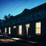
Daily Photo – White Horse Hotel (Former)

I’d arrived at the Blue Lake after leaving State Highway 85 and bouncing along a gravel road for a while before finally reaching the tiny settlement of St Bathans.

After standing in the snow for a bit, I left St Bathans via the Loop Road, heading towards the tiny town of Ophir via Lauder and Omakau. The road took me through the old gold-mining settlement of Cambrian, with banks of snow lying either side of the road and the surrounding hills looking decidedly wintry, before eventually rejoining State Highway 85 at Becks. These days, Becks is little more than a name on the map with a pub, but once upon a time it was an important stopping point on the Cobb & Co coach route between the Dunstan and Maniototo goldfields. With a pub, of course and little else. So maybe Becks hasn’t changed that much after all.

Curious for more? Explore more from a Small City.

Click here

The Doors of Perception: Infinite

Daily Photo – The Doors of Perception: Infinite

When Jim Morrison and Ray Manzarek formed the band The Doors in 1965, Jim Morrison proposed the name ‘The Doors’ to symbolise breaking through everyday reality into the unknown. However, it wasn’t an entirely original concept. Morrison was blending two of his favourite literary influences, William Blake and Aldous Huxley. In his poem The Marriage of Heaven and Hell, William Blake wrote: “If the doors of perception were cleansed every thing would appear to man as it is, Infinite.” Whereas Aldous Huxley borrowed Blake’s phrase for the title of his famous book about psychedelic experiences, The Doors of Perception.

So, when a name for the band was needed, “The Doors” immediately came to mind. While they weren’t talking about physical doors, but rather how the mind receives, filters and processes reality through the cognitive filters of human consciousness, it’s still fun to wonder what might be beyond the random ones that pop up unexpectedly. In this case, I like to think a Dragon named Droofus but it’s more likely to be a stack of chairs.

Fenceline In The Ida Valley

Daily Photo – Fenceline in the Ida Valley

Driving through the Ida Valley during a recent snow dump, the scenery shifted dramatically. About 15 minutes before reaching Oturehua, the sharp blue sky vanished, dissolving the landscape into a ghostly white.

I took this around 3 pm, but with the temperature hovering at a freezing −5°C, there was no warmth left in the air. The heavy hoar frost and low mist drained every trace of colour and sound, leaving only absolute silence. The icy fence line is the only anchor guiding the eye through the haze, making Central Otago feel less like home and more like the edge of the world.

Stone Cottage in The Snow at Blackstone

Daily Photo – Snow at Blackstone Hill

While exploring part of Central Otago during a recent snow dump, I passed this well-known cottage. On this occasion, the snow was piled high, creating what was almost a wall of snow on either side of the road. In a previous life, I believe this place was a general store and post office, meaning it would have been quite the community hub before people moved on and it spent many years as just another dilapidated building.

Rural Intersection At Dusk

Daily Photo – Main Street & Gimmerburn-Waipiata Road at dusk

With a few days free and a recent snowstorm having left much of Central Otago looking beautifully white, I headed off in search of snow photos. The plan was simple enough: drive until I found something interesting, stop far too often, and hope the weather cooperated. So, naturally, the first photo I post from the trip is a non-snow photo.

After spending the day criss-crossing the Maniototo, stopping whenever the light caught my eye, the landscape demanded another look or the snow got really interesting,  I eventually rolled into the tiny settlement of Waipiata. I found my accommodation, dumped my bags in my room, and immediately headed back outside. It had been a long day in the car and I needed to be outdoors for a bit. As dusk settled across the wide-open landscape, the last of the daylight softened the empty streets and surrounding hills, giving the little settlement the sort of quiet charm that only seems to appear at the end of the day.

The Magnificent Clutha River in Autumn

Daily Photo – The Magnificent Clutha River in Autumn

When I set out on this section of my trip, it had been my intention to stop in Roxburgh and call in to the Jimmy’s Pie shop (which just happens to be the best pie shop in the world, and I won’t hear a word against it) and grab some lunch. Unfortunately, it was Sunday and it was closed. So, instead I got some lunch in Alexandra and ate it sitting in the sunshine on the banks of the Clutha River, admiring the town bridge and the autumn hues reflecting in the river as it gently floated past.

Curious for more? Explore more from a Small City.

Click here

Still Lumbering Along the Gold Trail in Central Otago. 

Daily Photo – Lake Dunstan from the Clutha River Lookout

I was heading for Lake Pukaki via Cromwell and the Lindis Pass when I came across Lake Dunstan. It was a mix of dry, barren rock covered hills and lines of trees along the shore in the throws of autumn colour. The contrast really was quite lovely and all along the lake there were inlets and bays where people could launch boats, swim and picnic. Just before arriving at the town of Cromwell, I called in to one of these rest areas to take in the view. It also gave me a chance to read about two fellows from local history named Horatio Hartley and Christopher Reilly. Both seeming to have a restless spirit, the pair met on the California goldfields and by the time they landed in New Zealand, the gold rush party was well underway. Gabriel Read had kicked off the rush in the Tuapeka a year earlier, and while the rest of the world was frantically scrambling over worked claims, Hartley and Reilly were drifting quietly, almost invisibly, up the Clutha River.

As time ticked on, they pushed further into the hinterland, looking for something the others had missed, and It wasn’t until they hit a stretch of the Clutha River that their luck changed.  A brutal, bitter winter had dropped the Clutha River to levels rarely seen. It exposed the black sand, the shingle bars, and deep, rocky clefts where the gold liked to hide. Working quickly, while the rest of Otago were moaning about the “end of the gold era,” Hartley and Reilly were washing six ounces a day (about NZ$14,000 per day) out of the river. They kept it quiet of course. You don’t find a fortune and immediately go shouting about it. Eventually discovered by a prospector with the same idea, stories began to spread of the search for gold up the Clutha River.  

A few days later, the door to the Chief Gold Receiver’s office in Dunedin swung open and two dusty miners strode in and dumped 1,000 ounces of gold on his desk. For a reward of £2,000, they’d reveal the location and on September 23, 1862, the Dunstan goldfield was officially proclaimed, triggering an avalanche mayhem! Suddenly, names like Cardrona, Arrow, Whakatipu, Shotover, and St. Bathans were on everyone’s lips.

As for Hartley and Reilly, neither stayed to see the chaos they’d unleashed, they quietly drifted into the pages of history.

Autumn in Central Otago

Daily Photo – Autumn in Central Otago

I stopped in Alexandra long enough to grab some lunch and pay a small fortune for a tank of petrol. From there I headed towards Clyde, where I had planned to eat while taking in the view from a hillside lookout. The road slipped quietly out of town, passing row upon row of dark green conifers before giving way to farmland, with timber post-and-rail fences running alongside the road. Then came the scattered piles of schist, tussock, and dry grasses that define so much of the landscape in this part of the country. Beyond them,fruit trees carried their autumn colours, oranges and golds dominating the palette. All around, the hills, rocky and sun-bleached, rolled off into the distance. I stood at the Clyde Lookout and ate my lunch, taking in a view that stretched far beyond me as the mid-morning sun settled into the autumn day.

Curious for more? Explore more from a Small City.

Click here

Toward the Hawkdun Range

Daily Photo – Toward the Hawkdun Range

The valley opened out in front of me with wide, open spaces filled with nothing but pale tussock, each clump standing like a small island in a sea of dry grass. They stretched away in every direction, shaped by long Otago summer and a few decades of wind. Ahead, the land rolled upward in soft folds before rising sharply into the distant ridgeline of the Hawkdun Range. Up there the brown hills gave way to streaks of lingering snow, clinging stubbornly to higher gullies and shaded slopes. From where I stood the snow looked almost painted on, white lines cutting across the dark ridges like careless brushstrokes.

Heavy grey clouds hung low over the mountains, threatening rain, while a narrow band of blue held its ground above the ridge. Every now and then sunlight slipped through a gap and wandered briefly across the hills before disappearing once more.

I walked on for a while, partly because it felt good to move and partly because the valley had a an intriguing quality that’s hard to explain. The walk was refreshing, enjoyable as the mountain range loomed larger and larger the closer I got. It was somewhere around this point that a small but undeniable flaw in my plan became apparent. At some point I’d need to walk back!

I turned and looked behind me. The road ran all the way back across the valley floor toward Blackstone Cemetery, where my car was parked beside the gate. I began the slow trudge back to my car, some five kilometres away.

Gravel, Wind, and the Hawkduns

Daily Photo – Gravel, Wind, and the Hawkduns

I’d spent the best part of three days wandering around the Ida Valley in Central Otago, drifting between the small towns of Omakau and Ophir, and up into the hills around Poolburn. By the fourth morning, I found myself at Blackstone Cemetery, wandering among the old graves and a nearby abandoned schoolhouse that appeared to have closed its doors to the world some time ago.

The night before, I had stopped at the local pub in Oturehua for dinner and a quiet pint. What followed was a thoroughly educational evening spent talking to the locals about the weather, the railway that used to run through the valley, sheep, and several finer points of farming that I almost certainly misunderstood. The beers arrived with alarming efficiency, and by the time I eventually stepped outside, my legs had developed a curious independence from the rest of my body.

Now, having showered, eaten, and injected several litres of caffeine into my system, I was beginning to feel almost human. I decided a walk might improve matters further.

Earlier, I had spotted a line on the map called Home Hills Runs Road, which seemed to strike a perfectly straight path toward the distant ridges of the Hawkdun Range. It looked short enough to manage without a total physical collapse, so I left the car by the cemetery gate and set off.

The road stretched ahead through endless tussock. There were no houses and no traffic. There was only the rhythmic crunch of gravel underfoot and a zephyr wind sliding across the floor of the valley.

Driving Through Clyde

Don’t forget you can click on the catergory names above each post to see more photos related to that place. For example, you can give it ago here with Clyde or Central Otago.


Daily Photo – Driving Through Clyde

I’d spent several days in Central Otago, in and around the Kawarau Gorge area, and on the way home, on a whim, I called in at the Clyde Dam lookout. It was at that point that I spotted this view of the Clutha River winding its way under the Clyde Bridge with the stark, barren hillside beyond the far away town of Alexandra only adding to the and a sense of emptiness and seclusion that is such a feature of  this area of the country. Fortunately, I had plenty of time on my hands, so I detoured down into the town of Clyde and had a lovely wander around for half an hour or so in the afternoon sun. 

The Solitude of Central Otago

Daily Photo – The solitude of Central Otago

A few days later I left the shores of Lake Wakatipu and nearby conservation areas such as Mount Aspiring National Park. I headed in a roughly east-north-easterly direction for nearly two hours past towns like Clyde, Alexandra, and through the Ida Valley to Oturehua. I’d remembered about a general store called Gilchrist’s which is famous for being one of New Zealand’s oldest continually operating general stores. It still sells all sorts of quirky goods and is decorated with vintage advertising signs. I called in and wandered around. Afterwards and back in my car, I eventually rejoined state highway 83 where I was soon passing wide open- tussock covered plains that are a feature of the solitude of Central Otago.

The Road Home

Daily Photo – The Road Home

There’s something quietly revealing about standing alone on a long, empty gravel road, rain clouds drifting overhead and snow dusting the distant ranges. It’s the kind of place that either makes you want to turn back quickly or stay a while. When a cool wind lifted my hat and sent it tumbling, I took it as a sign. I sat by a nearby boundary fence and paused for a bit. Besides, I had a flat tyre to deal with, and the boot wasn’t going to unpack itself.

The Lindis Pass

The Linid Pass in Summer

The Lindis Pass is another stunning area of New Zealand, offering vastly different experiences depending on the season. In winter, it’s often blanketed in snow and ice, with caution advised when the road is open. In summer, the landscape transforms into a sunburnt, otherworldly terrain, its dry textures stretching across the hills. Set between the Lindis and Ahuriri Rivers, the pass was traditionally used by Māori as they journeyed through the land. In 1857, surveyor John Turnbull traversed the area and named it after his homeland—Lindisfarne Island in northeast England. 

When the Otago gold Rush took hold across the region in the early 1860’s, the moving hoard of miners who rambled from rush to rush eventually came upon the Lindis River in April, of 1861. An estimated 300 miners swarmed over the hillside as news of a find at the Lindis River spread. However by July most of the miners had moved on due to the remoteness of the area and the extreme climate. 

On a fine summer’s day, I stopped at the Lindis Pass lookout and decided to join the steady stream of people heading to the summit to take in the view. From the peak above the Omarama–Lindis Pass Road in Central Otago, the view across the pass is breathtaking—a reminder of the natural beauty and history that define this unique part of the country.

Gee’s Flat in the Kawarau Gorge

Kawarau River in the Kawarau Gorge

Tucked away in Otago’s history is the short-lived mining settlement of Gee’s Flat. It emerged during the height of the Otago Gold Rush as miners pushed into the rugged Kawarau Gorge, searching for new riches. By 1862, nearly 100 prospectors had set up camp here, battling the harsh terrain in hopes of striking gold. But mining at Gee’s Flat was no easy task. Water supply was unreliable, with miners depending on nearby creeks or the river itself fir a steady water supply. This was relatively easy when the river level was low, however when the river swelled, the dangers became all too real—flooding was common, and drowning became a consequence of life on goldfields near rivers.

The Bullock Track Walkway

Bullock Track Walkway

Leaving the town of Clyde, then Roxburgh, the drive to Beaumont and later Lawrence was uneventful. Having caught-up on all my podcasts and not feeling in the mood for music, I filled the time by making a list of random places and things in the area that I might like to visit.

By the time I reached the Beaumont Bridge, my list included:

Walk the Bullock Track Walkway.
Find that random shed in the Tiviot Valley I spotted.
Walk up to the Alexandra Clock. 
Visit the Gorge Creek Memorial.
Explore Conroy’s Dam.
Walk the Old Reservoir Trail.
Walk up to Flattop Hill above Butchers Dam. 
Visit the ‘Somebodies Darling’ grave near Millers Flat.
Visit the Fairlight Train Station. 
Find the Horseshoe Bend Bridge

Now, you might think that visiting the Jimmy’s Pie Shop in Roxburgh should be on the list, however it doesn’t qualify. Firstly, it’s far too obvious and not obscure or random enough and secondly, whenever I drive past, I stop off anyway.

A Walk In Clyde

The Lord of Clyde in Clyde

The town, while small, was surprisingly quiet. I hadn’t expected there to be the large crowds that filled the town in early January when summer is at its peak; however I thought it would be busier than it was. After a leisurely amble up and down the main street, I deduced it might be an in-between period of summer when all the locals have gone back to work, while those still in holiday mode are away at more exotic locations like Queenstown, Taupo, or Rotorua. Over the years, Clyde has developed from a sleepy little town filled with construction workers who were working on the nearby dam to a popular holiday spot that swells on weekends as people escape the city rush to pack the tiny town for a few days before heading back to work on Monday. 

I stayed in the town once during one of its more ‘busy’ periods. The summer evening was long and warm. It was really rather pleasant. In the evening, it took forever to find a free table at any of the various eating establishments and even longer to order food, which was very nice, once it arrived. Therein lies the problem with many of the more popular small towns in New Zealand: they become so attractive that they simply don’t have the infrastructure to handle the large crowds they attract. 

On this occasion, the town was bathed in warm summer sun. It was quiet, meaning the streets were free to stroll around and enjoy all the lovely offerings Clyde had on display.

The Clyde Dam

The Clyde Dam

With plenty of time left in the day, I stopped at the Clyde Dam lookout. When the dam was completed in 1993, it created Lake Dunstan and proudly holds the title of the country’s largest concrete gravity dam. It stands 102 meters tall, with a base width of 70 meters and a crest length of 490 meters. All of which is fairly small by international dam standards when compared against the Tarbela Dam in Pakistan or the Fort Peck Dam in the United States. But, it is the biggest in New Zealand, and that means something. 

The dam was constructed between 1982 and 1993 to reduce the country’s reliance on imported oil and to fuel industry, but it wasn’t without controversy. The decision to build the dam prompted vehement opposition, a court case, and even required an act of Parliament to get the project across the line. 

All of which means we have a giant dam that produces lots of lovely electricity and a wonderful big lake for swimming, fishing, and boating. But  there are some of us who would prefer to have the old Cromwell Gorge back, with its historic huts and plentiful fruit orchards. I thought about all this as I looked out across the dam. Then, deciding I was probably in the minority I got back in my car and headed down the hill into the nearby town of Clyde.

Lake Dunstan & The Cromwell Gorge

Jackson’s Inlet at Lake Dunstan

I left Queenstown Airport and spent the next 50 minutes driving to the town of Cromwell. I passed through the Gibbston Valley and the Kawaru Gorge and before arriving at the small, bustling town of Cromwell that was filled with people and bathed in bright sunshine on the shores of Lake Dunstan. Stopping for petrol and a bite to eat, a short time later I rejoined State Highway 8 and crossed the Cromwell bridge, now having the lake for company out of the right hand window. I rounded a bend and was greeted by a serene view of the lake. The lake looked warm, placid and tranquil as the summer sun took over the surrounding hills that once formed the Cromwell Gorge. Not being able to resist, I called in to an inlet for a closer look.

Lake Dunstan & The Cromwell Gorge

Lake Dunstan in autumn

Whenever I’m driving past Lake Dunstan I can never decide whether I actually like it. You see, when the lake was made after the Clyde Dam was completed in 1992, it flooded the spectacular Cromwell Gorge, taking with it many historical important settlements that’ll never be seen again. If you never saw the gorge, you have no reason to miss it, however if you remember the famous gorge, you’ll know how wonderful it was. 

It had dramatic cathedral-like rock formations on either side of the Clutha River that dropped dramatically to the river far below. The road, which connected Cromwell to Clyde and Alexandra twisted and turned through the valley, passing historic gold-mining locations that linked to the every origins of European settlement in the area with orchards of every description lining the river banks. Now, in its place is a stunning lake with mountain views and small inlets scattered along the shoreline, making it a popular spot for recreational activities like boating, fishing, and cycling along the shoreline trails. 

I pondered all of this while driving through the gorge. It was a crisp autumn day. I’d left the town of Cromwell and after several minutes I found myself driving past where the gorge had once been, stuck behind a campervan. Do I ever hate campervans! They take up entire lanes on the road, they constantly sway from side to side, they’re slow and they spoil the view. Plus, they always seem to be either lost or unsettlingly disoriented. I can’t tell you how much I loathe campervans!! On this occasion, I just happened to be following two of them, going slower than a snail suffering from a bad case of arthritis. Groups of geriatric’s with walkers could have passed us! So, I pulled into one of the rest areas by the lake to wait several weeks until they were far ahead of me. 

It was mid-morning and there was a cool crispness to the morning air as autumn leaves lined the shoreline. Across on the distant shore, the rocky hillside glistened in the morning sun. It was all very still and tranquil, yet I still missed the old gorge!

Olivers – The Benjamin Naylor Story

Olivers in Clyde

Speaking of gold, Clyde is another place that quickly went from being a tranquil, sleepy hollow beside a river, to a boomtown overrun with gold hungry miners. When gold was discovered in the gorge beyond where the town of Clyde now lies, chaos ensued. Within a year, in the vicinity of fifteen to twenty thousand miners were clambering along the banks of the river and surrounding gullies, seeking a fortune in gold. 

So it was that Clyde (then known as ‘The Dunstan’) became a confusion of shanties as calico tents and scantling huts shot up everywhere. Amidst the mayhem of the new town, as thousands of kilograms of gold was drawn out of the once quiet gullies, one new arrival at The Dunstan was Benjamin Naylor. Having been based in Gabriel’s Gully near Lawrence, he arrived with a wagon-load of supplies in 1862 once news of the gold discovery spread across the young province.  Affectionately known as ‘Old Ben,’ the merchant and farmer set up a tent store selling produce from his farm in the Manuherikia Valley to the grizzled, fortune seeker prospectors hoping to strike it rich.

The Clutha River at Roxburgh

The Clutha River at Roxburgh

Usually when I stop in the town of Roxburgh, it’s for one of two reasons: to grab a pie from the famous ‘Jimmy’s Pies’ shop or to stock up on fresh, seasonal fruit from one of the orchards. On this occasion, unfortunately the pie shop was closed, and I already had plenty of fruit. So, my plan was to drive straight through without stopping. That idea quickly changed as I rolled through the town. On a last-minute impulse, I decided to take a detour through an even smaller settlement called Millers Flat. I had no real reason, but it was nearby. As long as I crossed the river!

The Manuherikia River

The Manuherikia River

The Shaky Bridge spans the Manuherikia River. Standing on the bridge, I looked down as the river gently flowed past. It seemed to be in a lazy mood, like it didn’t have much to do and plenty of time to do it. I scrambled down a nearby bank for a closer look. The river was low and slow, lazily winding its way past Alexandra before joining the bigger Clutha River. Looking ahead, the edges of the bank reflected in the still water. Above patches of blue peeked through the breaking clouds above. The river didn’t seem in a rush-and neither was I, though I suspected it had a better excuse.

The Shaky Bridge in Alexandra

The Shaky Bridge in Alexandra

In the morning I awoke with a clear head, feeling refreshed and ready for a new day. This was somewhat surprising. Usually, after spending all day at a concert I would greet the new day with a hangover that could floor a rhinoceros! However, the previous day having made the very grown-up decision to remain sober while attending the Gibbston Valley Summer Concert, the morning seemed full of possibilities. What’s more, I was ok to drive! So, after breakfast, I decided to celebrate my new found maturity by visiting the historic Shaky Bridge in Alexandra.

Hayes Engineering In Oturehua

Hayes Engineering in Oturehua

The Hayes family homestead and engineering works really is an intriguing place and tribute to the term ‘No 8 wire thinking.’ The best thing about it is the fact that it hasn’t been modernised in the way that a lot of tourist attractions are these days. It’s presented in just the way it was used, as a backyard shed. In fact, an argument can be made for Ernest Hayes to be one of the original backyard Kiwi innovators (even though he was actually English!). Set amongst the rural backdrop of Oturehua in Central Otago, Hayes set-up his home and engineering workshop around 1895 where he invented all manner of agricultural tools, rabbit bait cutters, wind turbines and a patented wire strainer for applying tension to wire on farm fences. Which is still in production to this very day.

That Wanaka Tree

New Zealand’s most photographed tree in Lake Wanaka

That Wanaka tree is a determined wee thing. It started life growing from a fence post line that ran into the water around 1939 and has been going strong ever since. While locals remain somewhat confused about its popularity, the tree has been described as “New Zealand’s most famous tree” and “one of the most photographed trees in all New Zealand”. Unsurprisingly, it has become a tourist attraction in its own right.

The Alexandra Town Bridge

The Alexandra Town Bridge

As I passed through the town of Alexandra, I detoured to look at the former town bridge, a structure that is a true feat of skill and engineering. Built in 1882, the remains sit right next to the newer version that spans the Clutha River. The bridge, like the clock on the hill, is a bit of an icon.  While the newer version of the bridge is the one most people are familiar with, it’s the remains of the previous bridge that is the real monument. When it was built, it was one of the country’s most glorious structures and a true feat of engineering. These days, the surviving piers and towers are a testament to its wonderful construction, having withstood the force of the Clutha river for more than 140 years.

Alexandra

Alexandra in winter

I was heading to the Lindis Pass via Tarras. However, as I wanted to capture the early morning light through the pass, I decided to spend the night in Alexandra as this would allow me to get there in the morning light. Rising early, I ventured up to the Alexandra lookout that sits on the hill overlooking the town. It was a typical winter’s morning with the temperature sitting below zero and smoke from early morning fire’s drifting across the valley. In the distance, the first rays of sunlight took hold of the surrounding hillside. I spent a few moments taking in the silence before heading in the direction of Bendigo and later on the Lindis Pass.

Morning On Poolburn Road

Morning on Poolburn Road

Occasionally I find a subject by simple chance. Driving through the Ida Valley on Poolburn Road one day I found this small, isolated house constructed from stone and schist. Thinking it would make an interesting subject for a photo and assuming it was abandoned, I decided to call past it early the next morning on my way to Poolburn. Such unexpected and serendipitous moments appeal to my curious nature. They also require an openness to be guided by what the subject demands. In this instance I was drawn to the moodiness of the sky and the half light of morning which created questions for the observer to answer. Much like the house itself.

Naseby

Curling in Naseby 

By the time I arrived in Naseby the fog had cleared to reveal a beautiful, yet chilly winter’s day. Having taken a backroad as a shortcut, my first sight of the small town was of the Naseby Indoor Curling Rink and Adventure Park. A place that seemed incredibly busy for the middle of the week. Spotting a parking space, I squeezed my car in between two extremely large 4×4’s and proceeded to go for a wonder and find out just what attractions an Adventure Park on the Maniototo Plains holds. 

Across the road, in a stroke of what was simply dumb luck, I found a curling competition was taking place. Feeling rather pleased with my good fortune, I inquired with a few people who I assumed were locals if this was bonspiel? They quickly replied ‘no’ in between chuckles of laughter and explained that the ice wasn’t thick enough for that yet, however if the run of weather continued, they’d get close.  This, they went on to explain, was a local tournament. It was then that I sensed that I might be holding them up and as they seemed rather agitated and keen to get back to what was being referred to as the ‘ice’. Following them through a line of trees, I discovered a rather large gathering of people who were having the most wonderful time on a frozen outdoor pond. They were bundled up in winter gear, using brooms and curling stones on the ice. Nearby equipment and beverages were scattered along the edges of the pond, giving the whole scene a delightfully casual, community feel. I took some time to take in the surrounding landscape featuring tall trees and dry grass, while the light from the now clear sky cast long shadows across the ice. It really was the most peaceful, wintery atmosphere. And not one of them slipped over! A feat I was very impressed with.