Daily Photo – Winter on the Hawkduns

I’d been in the small settlement of Ophir and upon leaving I headed northwest over the Raggedy Range before dropping down into the Ida Valley. A wide, sunlit expanse where the air feels thin and clear, and the land rolls out quietly in front of you. It’s the sort of place that makes you slow down, breathe deeply, and wonder why more people don’t live in valleys like this. Then you realise how special it is and hope it never changes.
As I made my way through the wide-open expanses, the remains of a recent snow drift lay either side of the road, melting in the winter sun. In the distance the Hawkduns loomed, a great brooding mountain range dominating the skyline, the kind of mountains that make you feel wonderfully insignificant. The Ida Valley itself has a curious stillness, as if time slows down. Farmhouses sit low and square against the wind, fences run for miles into the distance, and the road stretches on so far ahead that it seems almost reluctant to end. There’s a sense this is a place built on endurance, of people who chose to stay even when the winters bite hard and the summers bake the earth into cracked clay.
I stood for a while on the side of the Ida Valley-Omakau Road, where the last of a recent snowfall lay dissolving into slush beneath my feet. Before me stretched the flat farmlands of the valley, sheep scattered across the paddocks searching for the remains of winter feed. Beyond them, the Hawkdun Ranges rose in a sweep of white, snow tumbling down their edges. It was one of those moments when the Ida Valley felt caught between two seasons, winter reluctantly loosening its grip while spring waited patiently somewhere just around the corner.
There’s something beautiful about the valley. Maybe it’s the silence, maybe it’s the long shadows stretching across the plains, or maybe it’s the knowledge that for generations this land has seen lives come and go, gold miners, farmers, railway workers and artists, yet somehow it has resisted change. History lingers in the dry air, tucked away in stone cottages, abandoned sheds and forgotten townships.
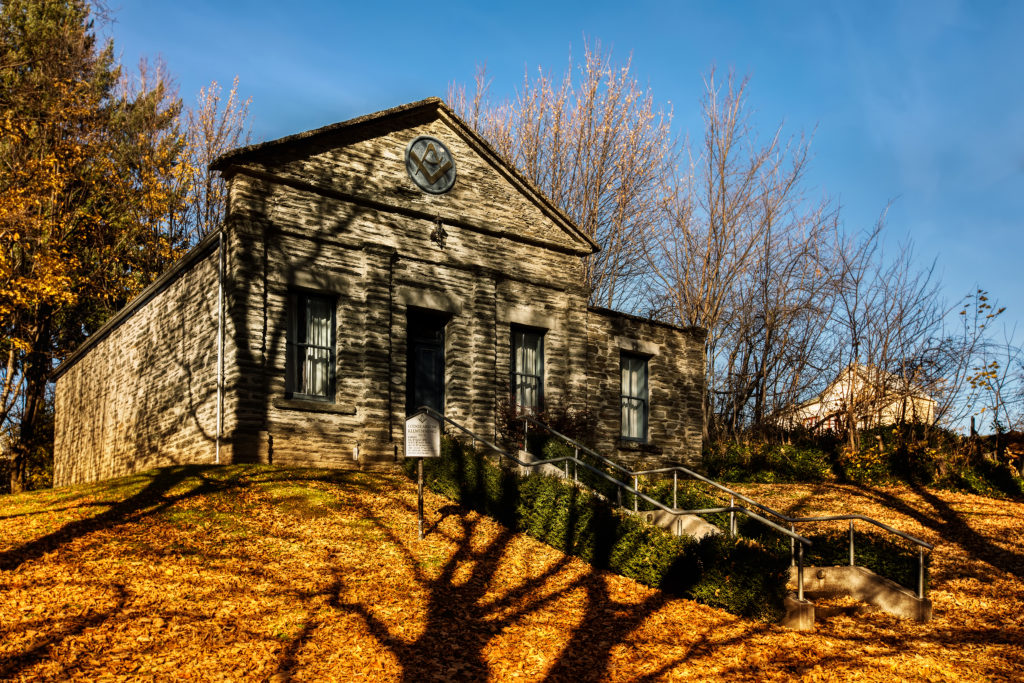
I was on my way to Oturehua after spending the afternoon exploring back-country roads, trying to get lost and generally avoiding inconvenient mishaps like flat tyres. Along the way I detoured off to Blackstone Hill Cemetery where, while admiring a rather large storm cloud advancing across the valley, I noticed an isolated building sitting alone on the hillside. Investigating further, I discovered it was the old Blackstone Hill Schoolhouse, built sometime around 1890. At one stage Blackstone Hill, or Hills Creek as it was also known, had been a busy settlement with no fewer than thirteen hotels. Today almost all traces of the place have disappeared, leaving behind only a cemetery, a few stone ruins and the weathered old schoolhouse standing stubbornly against the elements.
Eventually I rolled into Oturehua itself, one of those delightful little Central Otago townships that seems to exist quietly beyond the notice of the rest of the country. Officially known as Rough Ridge until 1907, it once supported a post office, telegraph office, flour mill, coal pits, railway facilities, a school, hotel and general store. These days the pub and the store remain, while much of the rest survives only in photographs and memory.
Not far from the township sits one of the Ida Valley’s true treasures, the old Hayes Engineering Works and Homestead. The place is a tribute to the idea of No. 8 wire ingenuity and to Ernest Hayes himself, one of New Zealand’s great backyard inventors, despite the fact he was actually English. Around 1895 Hayes established his workshop amongst the dry hills and paddocks surrounding Oturehua, where he began producing all manner of agricultural inventions including rabbit bait cutters, wind turbines and his famous patented wire strainer for tightening farm fences, a device still manufactured today.
What makes the Hayes Engineering Works so appealing is that it hasn’t been polished into some slick modern attraction. It still feels like a working backyard shed, as though Ernest Hayes has merely stepped away for smoko and might return at any moment. Fortunately, when I arrived the museum was open, though it was hard to tell from the roadside. Sitting beside the highway, it would be easy to drive past without ever realising one of the country’s great collections of rural ingenuity was sitting quietly behind the fence. On this particular day, however, the doors were open and I happily spent the morning wandering through the workshops, tools and machinery of a man whose inventiveness helped shape rural New Zealand.
Leaving Oturehua, I found myself taking a detour near Idaburn before eventually heading towards Waipiata by way of Wedderburn and Ranfurly. The Hawkdun Ranges kept pace out the left-hand window, stretching high into the vast blue sky beneath a magnificent sweep of snow, a clear sign winter still intended to linger for a little while longer.
Curious for more? Explore more from a Small City.
Click here